Cañas · Tonosí · Azuero Peninsula · Panama
Land for Sale near Playa Venao
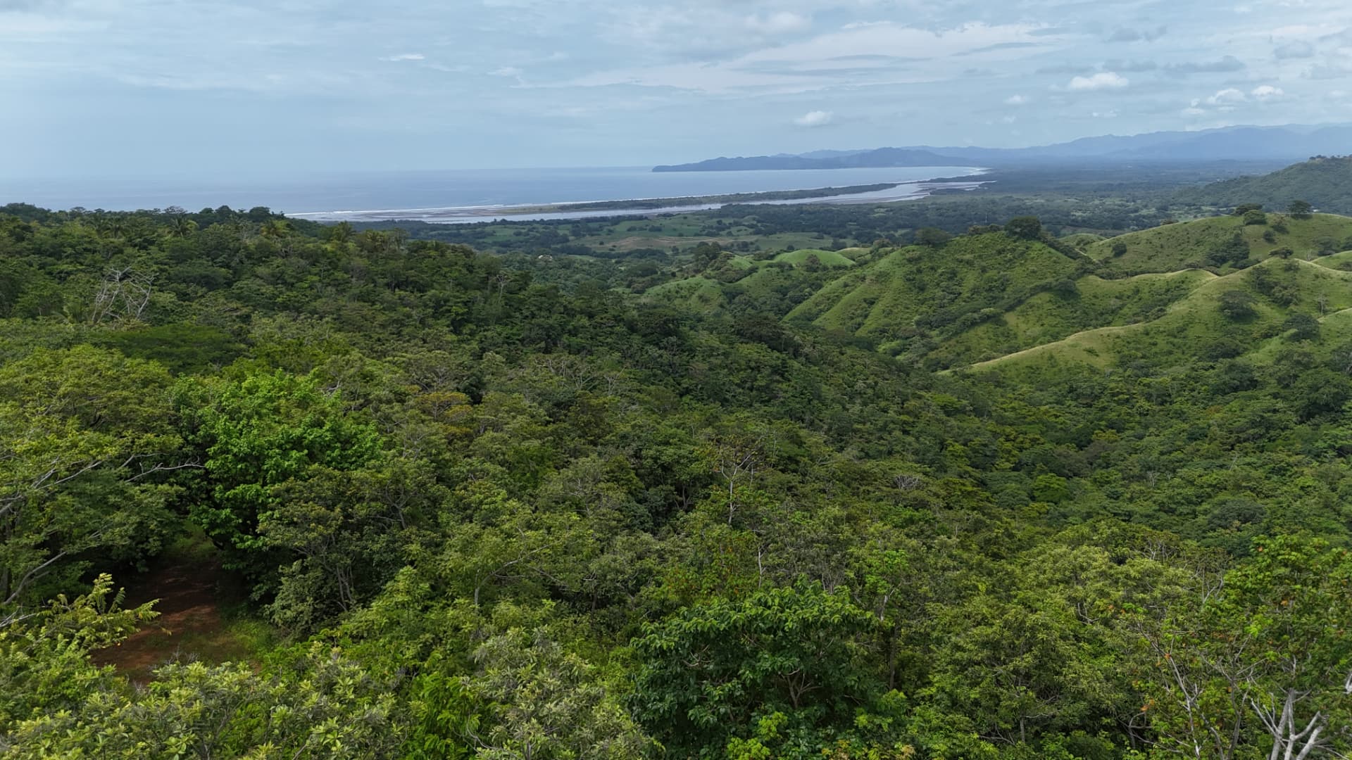
Approximately 64 hectares of private land in Cañas, Tonosí — approximately 15 minutes by car from Playa Venao, with views toward Isla Cañas and the Pacific from elevated areas.
Searches that begin around Playa Venao are usually directed at something specific: Pacific-facing Panamanian coastline within an established and recognisable region, and land with enough character to justify a long-term commitment.
Cañas Horizon is an approximately 64-hectare private landholding in Cañas, in the district of Tonosí, province of Los Santos, on Panama's Azuero Peninsula. It lies approximately 15 minutes by car from Playa Venao. It is not in Playa Venao, and it is not described as oceanfront. Across substantial elevated areas, the land opens toward Isla Cañas and the Pacific Ocean.
Looking Beyond Playa Venao
Playa Venao is an established coastal destination on this part of the Azuero coast, and it is frequently used as a geographic reference point for a much wider search area. Land searches in this part of Panama tend to extend outward from it — along the coast, inland toward Tonosí, and across the surrounding countryside — because the landscape qualities involved are regional rather than confined to one beach.
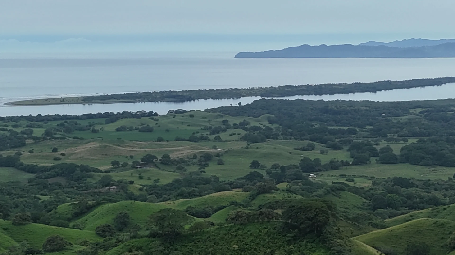
Cañas is one of those surrounding places, approximately 15 minutes by car from Playa Venao, and it has its own identity rather than being an extension of anywhere else. It is a coastal locality within the district of Tonosí, associated in most people's minds with Isla Cañas, the long barrier island lying off this stretch of the Pacific. The landscape here is open and predominantly rural.
Cañas Horizon illustrates the different scale of opportunity that can exist beyond the more intensively developed coastal locations: approximately 64 hectares held as a single property, where terrain, orientation and privacy can be considered as one whole.
A Different Scale of Landholding
Cañas Horizon is offered as one property of approximately 64 hectares — roughly 640,000 square metres. That figure is preliminary and remains subject to confirmation against the final survey, but the order of magnitude is what matters for anyone deciding whether to look further.
Land at this scale is evaluated differently from a building plot. On a single lot, the questions are about the house. On seventy hectares, the questions are about the land itself: how the terrain falls, where the elevated ground sits, which parts of the holding face the sea, what should be built on and — equally important — what should be left alone. A buyer is acquiring the ability to make those decisions rather than inheriting them from a previous subdivision.
Contexts in which land of this scale is typically acquired
- Private estate
- A single owner holding the land intact, with building confined to a small part of it.
- Low-density residential concept
- A small number of generously sized sites shaped around terrain and outlook.
- Hospitality
- A discreet, low-footprint operation using elevated ground and the surrounding landscape.
- Wellness or retreat
- A quiet programme that depends on privacy, orientation and undeveloped surroundings.
- Conservation-led concept
- Retention of the majority of the landscape, with minimal, carefully placed intervention.
These are potential directions that land of this scale can accommodate. They are not approvals, entitlements or commitments, and nothing here represents a plan that has been submitted or granted.
Views Toward Isla Cañas and the Pacific
Substantial elevated areas of the landholding look out toward Isla Cañas and the Pacific Ocean. That outlook is one of the property's defining characteristics, and it is also the characteristic most easily overstated, so it is worth being precise about it.
The views are not uniform. A property of this size covers varied ground, and the outlook differs considerably depending on where you stand: elevation, orientation and the intervening landform all change what is visible. Some parts of the holding are elevated and open; others are not. The property has no ocean frontage and is not described as oceanfront, beachfront or waterfront.
For a buyer, this is a design question before it is anything else. Where the elevated ground sits, how it is oriented, which corridors remain open and how any future building would sit within the contours are matters for terrain analysis and professional site studies — not for assumptions made from a photograph. The technical material being prepared for the property exists precisely so those judgements can be made properly.
Outlook descriptions are qualitative. No elevations, viewshed percentages or sightline distances are represented.
Why Cañas?
What can be stated
- Located in Cañas, district of Tonosí, province of Los Santos, Panama.
- On the Azuero Peninsula, facing the Pacific.
- Approximately 15 minutes by car from Playa Venao; the property is not located in Playa Venao itself.
- Associated with Isla Cañas, lying off this stretch of coast.
- Approximately 64 hectares held as a single property within a large-scale rural landscape.
Cañas is a coastal locality in the district of Tonosí, in the province of Los Santos, on the southern side of the Azuero Peninsula. The peninsula projects into the Pacific from Panama's southern coast and holds much of the country's traditional interior character alongside its more recently known coastal destinations.
What defines Cañas from a land perspective is the combination of Pacific-facing terrain and open, large-scale landscape. Isla Cañas lies offshore and is the feature the locality is most associated with. The surrounding land remains predominantly rural, and Cañas Horizon itself is held in single ownership as one property.
Its relevance to a Playa Venao search is one of market context: it belongs to the same broader coastal region that international buyers examine, while offering a different kind of property. We make no claims about relative pricing, growth rates or future values — those are not facts, and this website does not present them as such.
A Land Acquisition Backed by Technical Work
Land of this size cannot be assessed responsibly from photographs and a map. The value of a seventy-hectare holding lies in what the terrain permits, and that only becomes clear through survey and analysis.
A structured programme of technical material is therefore being assembled for Cañas Horizon: survey information and boundary verification, LiDAR capture, topographic modelling, terrain and slope analysis, and the wider due-diligence documentation a serious buyer's advisors will expect to review.
Each item is published on the technical page with its actual status — available, in preparation, pending or to be verified. Nothing is presented as complete before it is, and no figures are published before they are confirmed. Material that is ready is made available to qualified parties on request.
Potential, Not Prescription
It would be straightforward to publish a masterplan and a lot count. It would also be misleading. No masterplan has been approved for this land, and any figure of that kind would be an invention rather than an entitlement.
What can be discussed honestly is the range of directions a landholding of this scale and character can accommodate — a private estate, a low-density residential concept, hospitality, wellness, or a conservation-led approach that retains most of the landscape. These are framings for a conversation with a buyer, not a plan.
No approved masterplan is represented and no development approval is implied. Any future use remains subject to professional planning, legal, environmental and permitting review.
Review potential directionsLocated in Cañas, Near Playa Venao
Geographic hierarchy
- 01Panama
- 02Azuero Peninsula
- 03Los Santos
- 04Tonosí
- 05Cañas
Geographic clarity matters more than keyword proximity, so the position of the property is stated plainly rather than blurred into a nearby destination.
The landholding is in Cañas, in the district of Tonosí, in the province of Los Santos, on the Azuero Peninsula in Panama. Isla Cañas lies offshore and the Pacific Ocean is visible from substantial elevated areas. Playa Venao is a known destination approximately 15 minutes away by car and provides geographic and market context — not the property's address.
Beyond the approximately 15-minute drive to Playa Venao, no distances or travel times to the coast or to any airport are published on this website. Verified access and route information will be provided as part of the technical material once it has been confirmed.
A Private Land Opportunity
Cañas Horizon is offered privately, as a single property rather than as parcels. It is intended for a buyer prepared to evaluate land of this size properly: with their own advisors, against verified survey material, and on a timescale that allows real due diligence.
An Investment Memorandum is prepared for qualified prospective buyers, and technical material is released on request as it becomes available. Viewings are arranged privately. No asking price is published on this website, and no return of any kind is projected or promised.
Information on this website is preliminary. Areas are approximate and remain subject to verification.
For the questions specific to a site of this scale, see evaluating large development land near Playa Venao.
Explore Cañas Horizon
For further information, technical material or to request the Investment Memorandum, contact the Cañas Horizon team.